Baegundae return
Start and finish at 백운대탐방지원센터 on the Ui/Doseonsa side. The route is short on paper but steep, rocky and crowded near the fixed rails.
Allow 4–5 hours return, plus access timeView course →
SEOUL · 836 M
From the subway platform to the right gate, the granite summit and the way home.


“Partial control” does not tell you that your chosen section is open. Open the park’s control list on the morning of the hike, match the Korean course or section name, and obey gates and ranger instructions.
FIRST-TIMER ANSWER
“Bukhansan” is not one entrance. Your subway, bus stop and descent must match the route you choose.
Start and finish at 백운대탐방지원센터 on the Ui/Doseonsa side. The route is short on paper but steep, rocky and crowded near the fixed rails.
Allow 4–5 hours return, plus access timeView course →Enter from 북한산성입구, pass the fortress corridor and climb toward Baegundae. Longer, but easier to understand as a continuous valley-to-summit journey.
Allow most of the dayView course →Use the Ui/Suyu side for a forest-and-ridge outing to 대동문. It avoids the final Baegundae rail section and works better when summit crowds or exposure feel wrong.
Still a real mountain hikeCompare routes →FROM KOREA NATIONAL PARK SERVICE
You do not have to climb to the summit to enjoy the park.
The park lists a 90-minute Bukhansanseong programme with a nature-observation trail and stories about Daeseomun and the fortress gates. It meets at 북한산성탐방지원센터, 45 Daeseomun-gil, Eunpyeong-gu.
Check the official reservation page for current sessions and availability. Ask whether English interpretation is available. Weather alerts can cancel a session; wait for booking confirmation before travelling.
Official programme and booking information ↗The park grades trails using slope, distance, surface and expected time. Check the official course description, entry-time restrictions and closures before choosing your route. An attractive photograph does not show every difficult section.
Park trails and grades ↗Source: Korea National Park Service · reviewed 23 September 2026. Programme schedules and trail access may change.
TAP A NUMBER
Map numbers match the route cards. Markers show planning points, not a GPS track.
FIVE USEFUL OFFICIAL COURSES
Distances and times below are the park’s one-way course figures. Add rests, summit queues, the approach from public transport and the return journey.
 1SHORTEST SUMMIT LINE
From Baegundae Hiking Support Center via Harujae and the shelter area to Baegundae. The last granite section uses rails and can bottleneck. Return the same way on a first visit.
 2HISTORY + SUMMIT
From Bukhansanseong Hiking Support Center through the fortress valley toward Baegundae. A longer but memorable first ascent with gates, valley scenery and clear landmarks.
 3FOREST + RIDGE GATE
A shorter official line to Daedongmun, useful when you want forest, ridge atmosphere and a historic gate without committing to the exposed Baegundae finish.
 4SHORTER BUT STEEP
A compact western-side climb from Bibong Hiking Support Center via Geumseonsa. Rock slabs can be slick; do not treat the short distance as an easy walk.
 5LONG RIDGE DAY
From Gugi Hiking Support Center through the southern ridge network to Samobawi. More navigation decisions and a longer return make this better after you understand the park.
Course names, order and official route cards: Korea National Park Service · Bukhansan ↗.
19 PHOTOGRAPHER-SHARED IMAGES
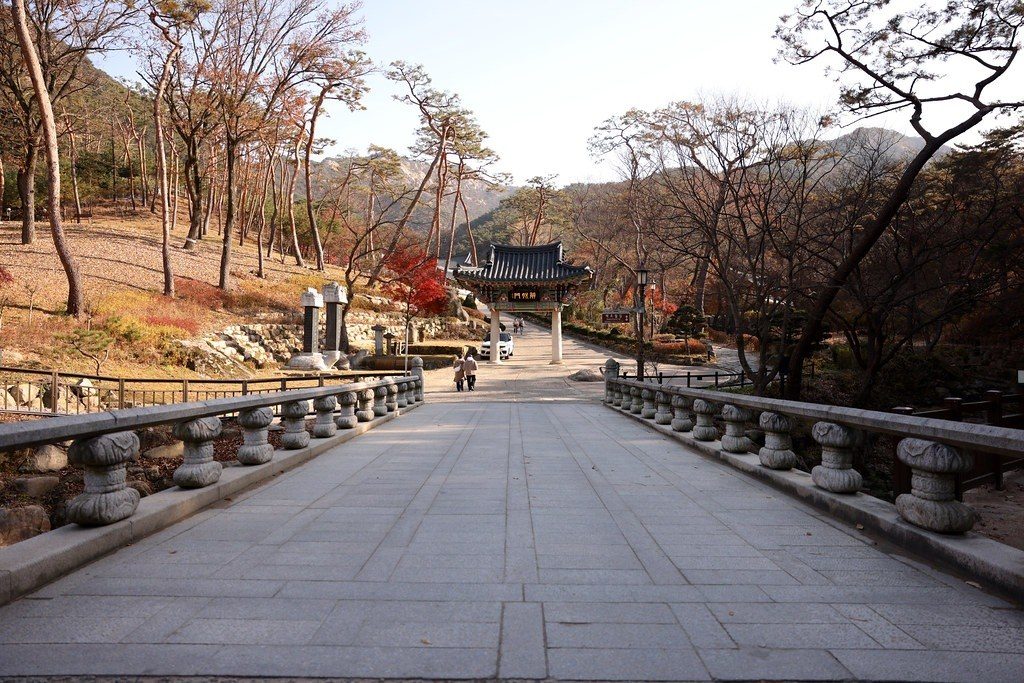
Explore more than the summit: granite peaks, fortress gates, a mountain temple, a woodland trail and the bridge at Jingwansa. Open each photograph for its original source and licence.




WHEN THE MOUNTAIN CHANGES THE PLAN
Granite, wind, ice and crowds can change a short route into a serious one.
Polished granite becomes extremely slick. Use traction in winter and never step outside the fixed safety line.
Do not follow a crowd. Match the Korean gate name saved on your phone before every descent junction.
Baegundae and open ridges offer little protection. Descend toward forest before conditions worsen.
Give the nearest 다목적위치표지판 location code. Park office: 02-909-0497; Dobong office: 031-828-8000.
GET TO THE RIGHT GATE
Transit routes change. Use the exact Korean destination below in Naver Map or KakaoMap on the morning you go.
Best anchor: 북한산우이역. From the terminus, walk uphill toward Doseonsa or use a taxi to the Baegundae support center.
Summit route · steep final graniteOpen map ↗Best anchor: 구파발역 Exit 1 or 2, then bus 704 or Yangju 37 toward 북한산성입구. The park lists about 10 minutes on foot from the stop to the support center; confirm the live service.
Fortress valley · longer summit dayOpen map ↗Best anchor: 수유역/우이동 side. Search the exact ranger-post name and compare the final bus plus walk before boarding.
Daedongmun course · forest/ridgeOpen map ↗Best anchor: 불광역 or 구기동 corridor. The last neighbourhood walk matters; pin the visitor-support point, not only Bibong.
Short distance · steep rockOpen map ↗Best anchor: 불광역/연신내역 with a local bus toward 구기동. Confirm the exact alighting stop in a live transit app.
Samobawi · longer ridge networkOpen map ↗The park lists the course, while live city transit should determine your bus on the day. Save both the outbound gate and the return stop.
BEFORE LEAVING THE HOTEL
These prevent the most common first-visit mistakes.
BASE
AFTER THE HIKE
Makgeolli is common near trailheads; save alcohol for after the hike and only when your transport is settled.
FOUR DIFFERENT MOUNTAINS

BEFORE YOU LEAVE
Check the official course page, individual controls, weather and daylight on the morning of your hike.
GANGBUK / COFFEE & AUTUMN
마음에 드는 카페부터 고르고 출발지에서 매장까지 이동을 확인하세요. 정상 등반 없이도 카페를 즐길 수 있습니다. 다섯 곳을 하루에 모두 돌 필요는 없습니다.
우이동에서 쉬어갈 카페 후보입니다. 방문 전 운영 여부와 정확한 입구를 확인하세요.
서울 강북구 삼양로181길 142
영업·주문 마감·대관 일정·주차 조건·계단과 승강기·어린이와 반려동물 규정을 매장에 확인하세요. 산행은 별도 코스와 탐방 통제 확인이 필요합니다.
출처 확인 2026-11-07 · 영업시간·가격은 별도 확인 필요북한산 자락의 한옥 카페입니다. 카페 운영과 대관으로 인한 이용 제한을 출발 전에 확인하세요.
서울 강북구 삼양로173길 223
영업·주문 마감·대관 일정·주차 조건·계단과 승강기·어린이와 반려동물 규정을 매장에 확인하세요. 산행은 별도 코스와 탐방 통제 확인이 필요합니다.
요청하신 ‘선운’은 선운각을 기준으로 준비했습니다. 업체명 확인이 필요합니다.
출처 확인 2026-11-07 · 영업시간·가격은 별도 확인 필요한국관광공사에서 은행나무 풍경으로 소개한 4.19카페거리 카페입니다. 단풍 상태는 계절과 날씨에 따라 달라집니다.
서울 강북구 4.19로 105
영업·주문 마감·대관 일정·주차 조건·계단과 승강기·어린이와 반려동물 규정을 매장에 확인하세요. 산행은 별도 코스와 탐방 통제 확인이 필요합니다.
출처 확인 2026-11-07 · 영업시간·가격은 별도 확인 필요커피와 빵을 즐기는 1층 테라스·5층 루프탑 공간입니다. 야외 이용은 날씨와 운영 상황에 따라 제한될 수 있습니다.
서울 강북구 4.19로 135
영업·주문 마감·대관 일정·주차 조건·계단과 승강기·어린이와 반려동물 규정을 매장에 확인하세요. 산행은 별도 코스와 탐방 통제 확인이 필요합니다.
출처 확인 2026-11-07 · 영업시간·가격은 별도 확인 필요계곡 가까이 통창과 테라스 풍경을 즐기는 우이동 카페입니다. 관광공사 안내에 어린이·반려동물 이용 제한이 있어 사전 확인이 필요합니다.
서울 강북구 삼양로181길 56
영업·주문 마감·대관 일정·주차 조건·계단과 승강기·어린이와 반려동물 규정을 매장에 확인하세요. 산행은 별도 코스와 탐방 통제 확인이 필요합니다.
출처 확인 2026-11-07 · 영업시간·가격은 별도 확인 필요숙박·지역 맛집·체험 업체의 제휴 안내와 업체 등록을 확인하세요.
제휴업체 사이트 보기 ↗시범 제휴로 소개하는 채널입니다. 영상은 유튜브에서 직접 열립니다.
유튜브 채널 보기 ↗Korea Beyond Seoul Online에서 여행 계획을 이어가고 통합 여행정보 검색으로 장소를 비교하세요.
여행 계획 사이트 열기 ↗Bukhansan cafes · 통합 여행정보 검색 ↗READY TO PLAN?